Sail Flow St. Pete
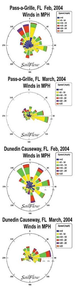
For the 2005 sailing season, North Sails once again provides its Expert Weather Online service for competitors at the Lands’ End NOOD regattas. To receive your own weather reports on wind and weather conditions for each day of any NOOD regatta, go to North’s Expert Weather and sign up. A complementary service-Sailflow’s historical and real-time wind and weather- is now available also. The service gathers wind information from dedicated sensors near each Lands’ End NOOD racing site. Check out what the wind’s doing on Tampa Bay right now by clicking this Sailflow link. St. Petersburg, Tampa Bay Late Feb conditions (written by Sailflow meteorologists) The typical late Feb. Tampa Bay pattern is largely controlled by the passage of cold fronts sweeping in from the NW. These fronts introduce veering and unstable north-northwest flow, followed by north then eventually northeasterly flow characterized by gusty and shifty conditions. in near-shore zones. Larger scale, and longer period oscillations in speed and direction typically are seen farther away from the shore. February post cold frontal blasts from WNW, NW or NNW are some of the strongest directions and certainly generate the gustiest conditions. The Dunedin Causeway and Pass-a-Grille Sailflow sensors show the relatively high frequency of winds from these directions in February but decreasing into March when easterlies once again become the prevailing direction. The days following a cold frontal passage usually see synoptic (large scale) directions veering to N and NE, with the strength of the gradient flow moderating markedly. As high pressure builds from the NW, less synoptic forcing allows sea breezes to become a more dominant feature along the coast. The geography of the region often results in the sea breeze front becoming stationary over St. Petersburg causing extended periods of mostly calm conditions that can last well into the afternoon. Cumulus clouds observed to the west, and clearer conditions advancing from the east are a sign that the sea breeze is beginning to propagate inland. The initial sea breeze may onset from the SW into the mouth of Tampa Bay from the Gulf long before a more westerly sea breeze makes it across St. Petersburg and into the bay. The initial onset therefore may often see stronger SW pulses before veering to a lighter and more fluky westerly. Given the variable nature of winds that are driven by considerably different forces this time of year, real time data and short range forecasts become an invaluable tool to make the best decisions.


