ChicagoWeather07
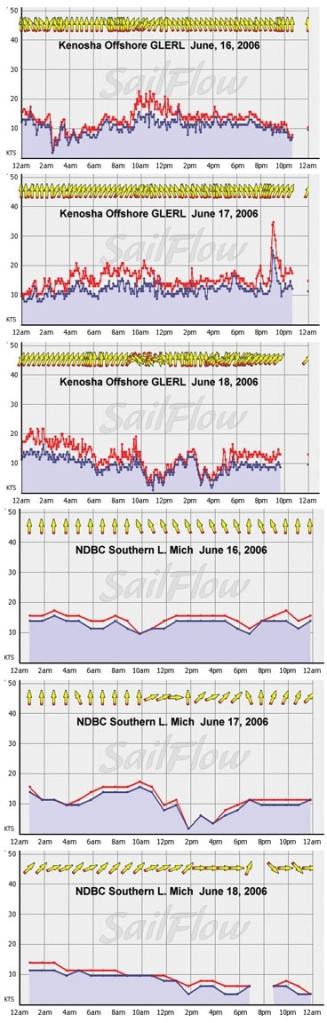
Early summer winds around Chicago are are combination of lake breezes on synoptic weak days but more dominant is often the ongoing battle between the cool Canadian air masses and the warming tropical aimasses that slip north out of the Midwest. Looking at last year’s NOOD Chicago winds we saw a primarily SW gradient wind as strong high pressure slowly slipped east of the race area and a cool front took it’s time shifting towards the region. Enclosed are graphs from the NDBC Buoy offshore and also from Kenosha GLERL that give a good generalization of the winds that were experienced on the race course last year. The offshore GLERL Chicago sensor was offline last year but this year it is back so this should be a good source of real-time data for the race.A few things to note on last year’s graphs: Typical of a south and SSW gradient wind in the early Spring, the flow brings on warmer air and thus has a hard time mixing over the still cool lake waters. On day one of the race the winds were very fluky with shifty south to SSW flow through the morning but once the surface heated enough to mix the winds from aloft we saw sudden gusts to 20 knots close to shore but not as much offshore. Day 2 saw a stronger and more turbulent SW gradient wind thus the winds filled in earlier and stayed a bit more consistent through the day. By day 3 we saw the strongest gradient winds as a cool front swept onto the region and these strong SW winds, though still quite warm, saw enough turbulence near shore to see gusts to low 20s much of the morning. Day 3 also saw a line of storms that came in during the midday. Typical of these storms we see a sudden burst of South and WSW flow ahead of the storm then weaker winds behind it. Note the delay in the wind recovery as the storm rain cooled the surface and the still warm SW winds once again lifted off but slowly recovered until the next rain line moved in. Now for this year’s outlook. Last week we saw a stalled Low off the eastern Seaboard and this stationary pattern kept a persistent area of High pressure over the great lakes. Models anticipate the ridge shifting east and a developing area of Low pressure to pull east towards the region and this weekend may offer another round of warm SW winds and some storm potential. Very similar setup to what we saw last year.The outlook and details subject to change as the race time closes in. Knowing what forces are driving these winds is of great importance to gaining the edge on your competition. Sailflow.com provides real-time sensors as well as forecast products complimentary through the race period at www.sailflow.com/chicago. In cooperation with North Sails, Sailing Weather Service is offering free precision race forecasts for this event. Sign up at http://na.northsails.com/ew/ew_main.taf


