TorontoWind06
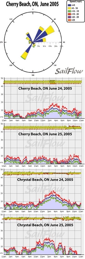
By the end of June, Toronto winds become less a result of synoptic (large scale) weather events and more dominated by localized lake breezes. The big factor for Toronto winds is the temperature difference between lake water and the city landscape, giving rise to lighter winds in warm wind scenarios (frontal passages) and stronger winds in pure lake breezes. The average day time high temperature is about 23 degrees C (low 70’s F) and June is neither a wet month nor a dry month, with an average of 68mm of rain. Thunderstorms are common as are rapid temperature changes that can be as much as 30 degrees simply depending on if the winds are off the water. However the slightly cooler temperatures in Toronto mean fewer thunderstorms, with an average of 5 thunderstorms a month for June versus the average of 6 for both Chicago and Detroit. Late June winds in Toronto become much more dominated by local lake breeze patterns. An important feature to watch for is the positioning of the northern high pressure ridge. The strongest winds tend to occur with the ridge held off to the west and a prevailing easterly gradient. The weakest winds are when the ridge is overhead or to the north and we see a prevailing NW and WSW wind. Occasionally with the ridge to the east we can see a SW or SSW wind filling in but these tend to be spotty and unstable. Enclosed are 2 images: the first is a wind rose of the winds that we saw last June at Cherry Beach. Notice that the winds are really quite light (as compared to places such as Chicago and Detroit) but also that the strongest wind directions is most commonly out of the East and Northeast. Due to Lake Ontario’s east to west orientation, the easterlies can funnel up the lake and then be accelerated by lake breezes drawing flow into Toronto. Note that the other common wind direction on the wind rose is from SW. The SW flow is a very complicated wind for Toronto (this is what we saw in last year’s NOOD races) because a typical SW wind is a “warming” wind (it draws warm air from the south). Quite common here is that the cold nature of the lake will reinforce a low level inversion and these stronger winds will simply fly over the lake resulting in light and very fluky conditions. The graphs from Cherry Beach (Toronto) as well as Crystal Beach (western Erie) to show the contrast and how fragile the SW setup can be. Both race days last year saw a very similar SW setup but the first day was just slightly stronger to allow for mixing of the winds into Toronto but the second day was warmer and the winds dropped below threshold to mix over lake Ontario. Day one was a healthy SW wind day and day two was hot, light, and fluky. In these “iffy” SW wind days we tend to call the winds “fragile” as any cloud cover or subtle changes in gradient winds can mean the difference between 15 and 5. Knowing what forces are driving winds is of great importance to hold the edge on your competition. Sailflow.com provides real-time sensors as well as forecast products complimentary through the race period at . In cooperation with North Sails, Sailing Weather Service is offering free precision race forecasts for this event. Sign up at http://na.northsails.com/ew/ew_main.taf


