Detroit Windrose 2006
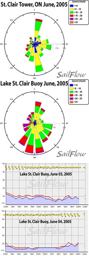
Light localized lake breezes often dominate summertime winds on the Great Lakes. But occasionally we can see weak frontal systems breaking through the southern ridge to give some varying weather and stronger winds. The National Data Buoy Center has a buoy in the middle of Lake St. Clair and Environmental Canada has a tower not far from the buoy. These hourly public sensors straddle the middle of Lake St. Clair, but often don’t reflect real conditions on the racecourse as winds can vary greatly between the middle of the lake and the shores. The two new Sailflow stations on the lake will be a key source of data to help gauge this variation. The buoy and tower are quite handy for examining historical wind trends and we have attached two wind roses below from last June to show the typical wind climatology. Notice that for two sensors located not far from each other these images are very different. Also notice that the winds don’t really concentrate on a single direction but are spread all around the compass-note the red sections from every direction. Some of the results seen in the wind roses can be explained by the Bermuda High, which will typically set up shop along the East Coast during the late spring, resulting in a light, primarily SSW, gradient flow. This bias to a Southerly flow is reflected well on both wind roses. It’s safe to say that as a rule of thumb, if there isn’t any large-scale system affecting the flow, variations on southerly winds will typically dominate. In cases where the gradient is very weak, one will often experience a lake-breeze day. A typical “pure lake breeze” day may start early on with a land breeze off of the city front from the WSW. But this breeze will fade and back to a southerly flavor by mid morning. With good sunshine expect to see localized winds dominate the flow giving quite shifty conditions through midday as the lake breezes undercut the warm SW flow. Strongest flow will typically be where the lake breeze can align with the prevailing flow. In this case, that would happen in the northeast quadrant of the lake. Winds settle out into evening as the sun hits the horizon and often will shift back to the SW for most locations. The above is for a “pure lake breeze” which is totally idealized. In reality we often see weak cool fronts that try to pull in when the Bermuda High weakens enough to the east. Sometimes these fronts can drive up SW and then NW flow as well as produce rain and thunderstorms. Even an occasional occluded front can give a few days of easterly winds. That is what happened last year as East and ESE flow set in during the race both days but it was fairly weak (see daily wind graphs for the 2005 Lands’ End Detroit NOOD). In fact you can see that on the second day the winds veered to the south and crossed the lake as the easterly gradient gave up and localized breezes began taking over. Given the fairly light winds during this time of year, the localized winds’ interaction with the gradient winds are key to knowing what to expect. Real-time data and short-range forecasts are paramount to keep the edge on the competition. Sailflow is your source for real-time information from exclusive coastal sensors and proprietary model forecasts. This information is complimentary now and through the racing period at http://www.sailflow.com/detroit. Sailing Weather Services is an excellent source for local and offshore racing forecasts. In cooperation with North Sails, Sailing Weather Service is offering free precision race forecasts for this event. Sign up at http://na.northsails.com/ew/ew_main.taf


