ChicagoNOODRoses
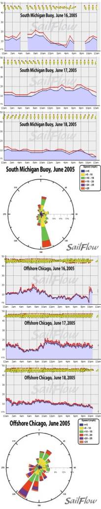
Chicago area winds in June teeter on the edge of a number of potent forces. Wind prediction is often a tricky art in this region because winds can vary quite drastically over a fairly small area. Not only are lake breezes an important factor, but the region resides in the early summer battlezone between cool dry Canadian air and hot humid Gulf air. Quite often the weather is dictated by where the frontal boundaries set up. Enclosed are two Wind Roses for the month of June in 2005. Data is courtesy of Great Lakes Environmental Resources Lab and the National Data Buoy Center. The GLERL sensor is located just offshore of the Chicago Cityfront (Offshore Chicago) while the NDBC site is towards the middle of the lake (South Michigan Buoy). Notice that last June had a strong tendency for SW and NE flow indicative of a very turbulent month with frequent frontal passages. June is a transitional month as it typically starts with very turbulent weather due to the many cold fronts, warm fronts, and occluded fronts pounding the area and ends with slower features and stable high pressure. Thunderstorms are quite common as are rapid temperature changes that can be as much as 30 degrees simply depending on whether the winds are off the water or not. Cold fronts can offer some frustrations to tacticians as Lake Michigan water temperatures take a long time to rise; yet the air masses preceding a cold front can be very hot. Thus west and southwest winds that howl in the city can be all but missing along the waterfront until the cold air inversion breaks down. Warm fronts and stalled occluded fronts offer their own complications as cold and showery ESE to NE flow can stay in place for several days until these slow systems can clear the region. It was one of these stalled fronts that held south of the region through last year’s Lands’ End Chicago NOOD Regatta. As high pressure built north of the region we saw some healthy NNE flow through the first races then gradually the winds let off as the front drifted south. The attached graphs show how the showers affected the region’s winds on Friday (June 16th) then pleasant weather and healthy NNE winds built in on Saturday (June 17th) and slowly decayed into Sunday (June 18th). As the month of June progresses we see the frequency of synoptic events (frontal passages) reduce and occasionally we see high pressure taking hold. The longest days of the year are during this time and often one can see temperatures in the city rising to the 90s while at the same time the waters of Lake Michigan remain in the mid 60s. This tremendous temperature difference can generate some healthy inshore winds with a strong lake breeze engine in place. The urban heat island of Chicago is a good magnet for these winds and thus typical lake breezes begin from the NE and veer to the ENE as they gain in strength. With the heat island we tend to see the lake breezes holding well into evening with just a gradual let down in flow. In the absence of any weather features such as frontal boundaries, expect these lake breezes to dominate. Knowing what forces are driving these winds is of great importance to gaining the edge on your competition. Sailflow.com provides real-time sensors as well as forecast products complimentary through the race period at . In cooperation with North Sails, Sailing Weather Service is offering free precision race forecasts for this event. Sign up at http://na.northsails.com/ew/ew_main.taf


