Marblehead NOOD Windrose
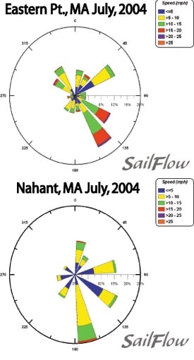
Summertime weather in New England tends to be dominated by persistent ridging which leads to weak and fleeting weather systems with light winds, warm often humid air temperatures, and sea breezes. July is often the lightest wind month for much of the US East Coast. However, for the north shore of Massachusetts we typically see sea breezes filling in almost like clockwork with an afternoon peak of SE flow. Three years ago Sailflow installed its weather sensor at Eastern Point Lighthouse in Gloucester and we were surprised at both the regularity and the strength of the afternoon sea breezes. A typical Sea breeze will initialize with an east to ESE direction then will gradually veer through the day as it strengthens. Peak winds will typically be between 3-5pm this time of year then winds slowly fade into evening with a very slight backing. Simply put, a sea breeze is a wind generated by the difference in air temperatures (densities) between air over the ocean and air over the land. With daily sunshine and surface heating, the inland temperatures rise and this creates less dense air inland and the cooler and denser marine air surges inland. Peak winds will typically occur a few hours after maximum heating of the day. The trick to estimating the potential strength of the sea breeze is to think of what will enhance or suppress the inland heating. While the timing and trending of the sea breezes is fairly regular with the proper setup, subtle atmospheric differences can affect strength that the breeze reaches. Humidity is a variable that can affect sea breezes as sometimes New England can get assaulted by tropical air that gives weeks on end of very humid and hazy conditions. This will tend to reduce sea breezes as much of the surface heating goes into heating the water in the air and not the immediate surface thus high humidity days tend to see a slightly weaker sea breezes. Similarly these setups often see afternoon cloud buildup and cloud cover will lessen the inland heating and also result in weaker sea breezes. The strongest sea breeze situation tends to be when we see a cool front pulling off of New England that gradually fades. The westerly flow behind the front tends to see a slight downsloping to the coast which heats the winds thus an early westerly will tend to heat the inland temperatures rapidly. The dry airmass allows the solar heating to go mostly into heating the surface. After a weak offshore morning, the sea breezes come on suddenly and strong. Occasionally this setup can push 18-20 knots into late afternoon. Knowing what forces are driving the winds is of great importance to gaining the edge on your competition. Sailflow.com provides real-time sensors as well as forecast products complimentary through the race period at www.sailflow.com/marblehead In cooperation with North Sails, Sailing Weather Service is offering free precision race forecasts for this event. Sign up at http://na.northsails.com/ew/ew_main.taf


