Larchmont wind rose
September is a transitional month for the weather in Long Island Sound, with normally light summer breezes giving way to stronger winds in more frequent weather events. The month starts with a lingering summertime feel, under slow moving weather systems but as the month progresses we tend to see more dynamic weather.
A common setup for early Fall is a surface high pressure center over New England that gives cool conditions and a weak E’ly tendency to the winds. In the morning the east/west orientation of the Sound tends to channel, even accelerate this E’ly flow. By afternoon the thermal gradient frequently becomes the dominant influence, with any daytime heating killing the ENE’ly flow before a S’ly sea breeze can fill in.
For this reason understanding the thermal gradients is key to determining the weather in Long Island Sound. By September the air temperatures reach an average high of around 76, which is only a degree or two warmer than the water in Western Long Island Sound (currently 74-76 degrees F according to the latest AVHRR Satellite images). This means thermal gradient effects are very dependent on the daily temperatures and are often weak. Most frequently you will see the north side of the Sound subject to an early land breeze, which gives a prevailing northerly to north-northwesterly wind, but is quite weak. With enough daytime heating the breeze will veer to a southerly flow in the afternoon. This sea breeze can sometimes get into a pulsing pattern with some low to mid teen gains, close in to shore. The south side of the Sound rarely sees any significant thermal effects at this time of year.
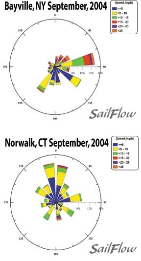
The virtually landlocked nature of the sailing area around Larchmont leaves the weather subject to many localized tendencies that make wind forecasting challenging. Looking at the 2 enclosed windroses for last September, you can see a drastic contrast from 2 sensors on either side of Long Island Sound. The most striking difference is the obvious tendency for ENE winds along the north coast of Long Island and the very diverse directions experienced along the south coast of CT/NY. Depending on the time of day and the strength of the prevailing easterlies one can experience a wide variety of winds with so many forces competing for dominance.
To further complicate the issue, the above is a description of just one atmospheric setup and the complexities it presents for this region. We chose to focus on it as last year (and last week) this setup dominated. September is on average the wettest month of the year, so while the above description is the dominate pattern, other setups, such as warm and cold frontal passages, may occur during this race period.
Passing cold fronts bring in their own complexities because this time of year they tend to not be very strong. Prefrontal SW flow tends to be very spotty with frequent left shifts due to sea breezing undercutting the warmer and stronger flow aloft. Post frontal winds can sometimes give windows of gusty NW flow but the weak fronts of early Fall tend to result in narrow windows but wide distribution of wind.
Knowing what forces are driving the winds is of great importance to gaining the edge on your competition. Sailflow.com provides real-time sensors as well as forecast products complimentary through the race period at http://www.sailflow.com/Larchmont In cooperation with North Sails, Sailing Weather Service is offering free precision race forecasts for this event. Sign up at ** **
