Detroit Windrose
Detroit winds at this time of the year can be quite a challenge to forecast for. Summertime winds on the Great Lakes are often dominated by light localized lake breezes but occasionally we can see weak frontal systems breaking through the southern ridge to give some varying weather and stronger winds.
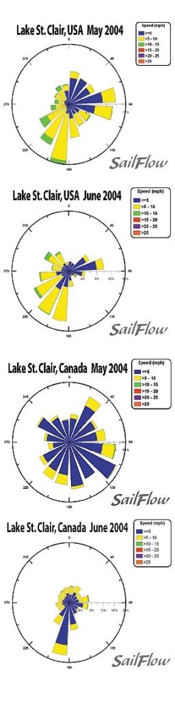
The National Data Buoy Center and Environmental Canada each have established Buoys located on their respective sides but straddling the middle of Lake Sinclair. These are very handy for examining historical wind trends and we have attached 2 wind roses below from last May and June. Notice that for 2 sensors located not far from each other these images are very different. Also notice that the colors of the graphs indicate that there is not a lot of wind during this period with the majority of days being 10 knots or less.
Some of the results seen in the wind roses can be explained by The “Bermuda High” which will typically set up shop along the East coast during the late spring resulting in a light primarily SW gradient flow. This bias to a SW flow is reflected well on both sensors, especially for the month of June.
In cases where the gradient is very weak one will often experience a Lake breeze day. A typical “pure lake breeze” day may start with a land breeze early on off of the city front from the WSW but will fade to a generally SW flavor by mid morning. With good sunshine expect to see localized winds dominate the flow giving quite shifty conditions through midday as the lake breezes undercut the warm SW flow. Strongest flow will typically be where the lake breeze can align with the prevailing flow and that would be in the northeast quadrant of the lake. Winds settle out into evening as the sun hits the horizon and often will shift back to the SW most locations.
The above is for a “pure lake breeze” which is totally idealized. In reality we often see weak cool fronts that try to pull in when the Bermuda High weakens enough to the east. Sometimes these fronts can drive up SW and then NW flow as well as produce rain and thunderstorms. Even an occasional occluded front can give a few days of easterly winds. Another common setup we see with a weaker eastern High is a thermal trough that develops along the lake axis between Erie and Ontario. This can pull synoptic flow to the WNW in the afternoon giving a healthy gain and favor the southern side of the lake where we have lake breezes, NW flow, and the sheer induced flow all adding up. Indeed looking at the graphs the NW flow doesn’t occur all that often but when it does the flow jumps into the 10-15 knot range.
Given the fairly light winds during this time of year the localized winds’ interaction with the gradient winds are key to knowing what to expect. Real-time data and short-range forecasts are paramount to keep the edge on the competition. Sailflow is your source for real-time information from exclusive coastal sensors and proprietary model forecasts. This information is complimentary now and through the racing period at . Sailing Weather Services is an excellent source for local and offshore racing forecasts. In cooperation with North Sails, Sailing Weather Service is offering free precision race forecasts for this event. Sign up at ** **


