Sail Flow Annapolis
**Typical late April conditions on Chesapeake Bay **** **
Chesapeake Bay, the largest estuary in the United States, is an extraordinary playground for sailors. While the weather conditions can range from hurricanes force winds to the stagnant jellyfish infested waters, typical early summer conditions on the Chesapeake are ideal for racing.
As winter draws to an end, the waters of the Chesapeake begin to warm and the jet stream starts to move north of the mid Atlantic region, taking much of the synoptic variability with it. However, synoptic forcing is still the dominant cause of early May weather. May is the wettest month of the year, with mostly convective precipitation and the possibility of severe thunderstorms along frontal boundaries. May also sees a substantial increase in temperatures, to an average daily high of 75 degrees F up from 65 degrees in April. Towards the end of the month the number of days with strong gradient winds decrease, and the Bermuda High becomes the dominant influence over the waters of the Chesapeake. This often leads to light fickle winds determined by local effects.
Some of the most important factors to consider when predicting the May winds in the Chesapeake include the strength of the pressure gradient, the potential for convection, the complex coastline, and thermal effects such as a sea breeze. In May, the pressure gradient is usually SW’ly around the NW periphery of the Bermuda High; however, to determine the strength of the pressure gradient it is important to know the proximity and strength of any local depressions. Thunderstorms and convective precipitation events are common in May, leading to gusty and erratic winds. However since the thunderstorms are often driven by synoptic forcing rather then just thermal gradients, the resulting wind shifts are somewhat more easily predicted. In anything but a strong gradient flow, the complex shoreline near Annapolis can lead to numerous wind speed and directional changes throughout the day. The flow over coastal development adds complexity, magnifying the gradient breeze, leaving wind holes, and influencing the development of sea breezes. On days with little or no pressure gradient, thermal effects that result from the temperature gradient between the land and water become an important influence on the wind direction. On days with background gradients from the SE veering SW the sea breeze will fill in earlier, whereas days with background gradients from the W or NW there will be little or no sea breeze development.
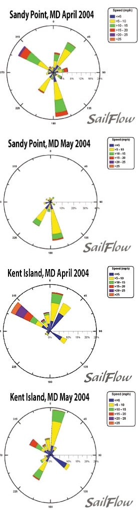
The windroses below are from the Sailflow.com sensors that are located on the east and west shorelines around the race area. Notice that the April winds tend to be much stronger and dominated by NW and NE winds typical of synoptic features. In contrast the May windroses show a weaker wind pattern with more frequent southerly and variable patterns that are more typical with sea breezes and localized effects. It is also worth nothing that the sea breeze fills more often at Sandy Point than it does at Kent Island, which may lead to large shifts across the bay.
With so many variables dictating the strength and direction of the breezes in the Chesapeake, real-time data and short-range forecasts are paramount to keep the edge on the competition. Sailflow is your source for real-time information from exclusive coastal sensors and proprietary model forecasts. This information is complimentary now and through the racing period at . Sailing Weather Services is an excellent source for local and offshore racing forecasts. In cooperation with North Sails, Sailing Weather Service is offering free precision race forecasts for this event. Sign up at ** **


