Boatspeed to Calculate True Wind Speed
With the increasing accuracy and update speeds of modern GPS units, it’s common for sailors to wonder whether using Speed Over Ground and Course Over Ground would be better than the old technology of paddlewheels and magnetic compass. In other words, is it time for us to throw away the paddlewheel and compass?
To begin with, let’s take a look at where SOG and COG come from, and if we can rely on them. SOG and COG are output from your GPS receiver. There are two methods the receiver can use to derive SOG and COG. The first and most basic is to measure the change in position from the previous fix to the present fix and calculate the speed and direction based on the time between fixes. The second, more complex and more accurate way, is to measure the Doppler shift between the received signal and the primary carrier frequency from the satellite.
Since the U.S. Government turned off Selective Availability in 2000 and WAAS was introduced in 2003, we have seen better position fixing accuracy and as a result more people using and relying on GPS. This has lead to some rapid technology advances and reduction of costs.
Until recently, most GPS receivers transmitted position, SOG, and COG data once per second, making it slow for the purposes of yacht racing. In the past five years, we have seen an increase in the number of GPS receivers on the market that output position, COG, and SOG at five times per second (5Hz). This is much more suitable for racing, especially in a starting sequence when the yacht is maneuvering a lot. Today, top-of-the-range GPS receivers, typically used for precision survey work, output data at up to 20Hz.
As this technology becomes more affordable, we will see it filter down from the America’s Cup and Volvo Ocean Race to become common on every boat. So technologically, with a fast updating GPS antenna and more accurate GPS position fixing, there’s little reason not to trust the accuracy of the SOG and COG data, but as a racing navigator we should question whether this is the correct data to be feeding into our instrument system and what impact it will have on other numbers down the line.
As their names suggest, speed over ground and course over ground are measurements related to solid ground. This means that using SOG and COG as accurate sources of speed and heading is fine if we are in a car, as we are in direct contact with the ground, but in a sailboat we have water moving independently between us and the sea bed. Even on a large freshwater lake, the water often moves compared to the ground.
If we want to be able to quantify the performance of our boat, we need to be able to measure our speed and heading through the water. This is best done with a sensor that measures water flow across the hull of the boat, such as a paddlewheel or ultrasonic speed sensor, and a sensor that measures the direction the bow of the boat is pointing in such as a magnetic compass, GPS compass, or, if the budget extends to it, a gyro compass.
If we rely on SOG as a measurement of boatspeed and we are sailing in waters with any current, we will struggle to reach our targets. With foul current, we will never reach our target boatspeed, and with favorable current we will out perform our targets, leading our crew to have little faith in the polars, the instruments, or worse still, the navigator.
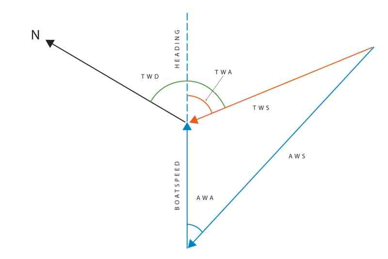
Most importantly, our instrument system won’t be able to calculate accurate sailing wind. Diagram 1 shows a simplified view of how we use boatspeed to calculate True Wind Speed (TWS) and True Wind Angle (TWA), and how we can use heading to calculate the True Wind Direction (TWD).
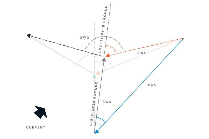
In Diagram 2, we can see what happens if we substitute boatspeed with SOG and we are sailing in an area with current. In this instance, the favorable current is giving us a faster SOG than speed through the water, but this is reducing our TWS and shifting our TWD. In fact, we are no longer calculating our True Wind Speed, but instead our Ground Wind Speed. The same is true if we substitute heading with COG, we are no longer able to derive the TWD, but instead we can calculate the Ground Wind Direction.
Ground wind has an important use on a sailing boat, it’s the wind that blows across the land and is what’s given in your weather forecast, but it’s not the wind that we are sailing in, so tactically—and navigational—it’s of little use outside of Optimum Routing calculations.
So if we cannot use SOG and COG for boatspeed and heading what can we use them for? If we combine an accurate speed through the water and heading with SOG and COG, we are able to derive the actual effects of the current on our boat. Some instrument systems will take this data and calculate the tide set and tide rate for us, which can have tremendous tactical advantages when racing in areas with significant tidal currents, such as San Francisco.
If you’re fortunate enough to be sailing on a boat where the difference between the boatspeed and the tide rate is very large (such as a large multihull traveling at 30 knots in a 1-knot current) then it would be safe to use SOG as a replacement for boatspeed without many issues. In fact, at these high speeds, SOG is often much more accurate than a paddlewheel sensor, so it has become common practice on large multihulls to use SOG from top of the range GPS receivers as a replacement for speed through the water, especially at higher speeds.
When we are out racing around buoys, or want to be sure we can lay a headland, COG is the essential piece of information to determine whether we’re making that mark or not. It’s good practice as a navigator to note your COG on each tack while sailing to a mark or, if you are using tactical software, to run a strip chart of COG for the past 15 minutes. As an example, if we are sailing up to the starboard layline on port tack, we should know what our last starboard tack average COG was, either from our “wet notes” or a strip chart. Provided the wind has not shifted, or the current changed, this will be the number that we want to see through the hand bearing compass when we tack, though there is still a large element of good luck involved in any layline call.


