GULauderdale368
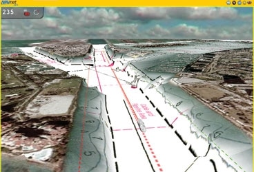
For those of us who cover marine electronics, this year’s Fort Lauderdale International Boat Show, held in late October, was a fun place to be. The show was rife with new product announcements and teasers for products to be announced early next year. Furuno’s NavNet 3D created much of the buzz. While I had heard whispers about the project for the last year or so, few details had been leaked. After seeing one of the final versions of this groundbreaking navigation system in action, I can see why Furuno was keeping things under wraps. NavNet 3D is an Ethernet-based navigation hardware system, the face of which is a Multi Function Display (MFD) (three sizes available: 8.4″, 12.1″, or larger custom monitors) combined with software from Furuno partner MaxSea, one of the icons of digital navigation. The result is the closest thing to seamless navigation (long promised, but never quite realized by any navigation software or hardware manufacturer) that we’ve ever seen. A powerful processor is part of the equation, as is plenty of RAM (MFDs are more than displays, they’re computers, and as such, benefit from fast processors and lots of memory), but the real reason NavNet 3D is so wonderfully cool to look at is that it also boasts a graphics processor. As any computer game aficionado (or the credit card-wielding parent of one) can attest, achieving smooth, realistic graphics is all about installing a good graphics card. The same holds true for digital charting, especially with the amount of information now available to today’s navigator.During the product release event for NavNet 3D, I sat with some folks I consider to be at the top of the journalistic heap when it comes to marine electronics coverage, Chuck Husick and Ben Ellison. While it became clear to me that both Chuck and Ben had been given a few sneak peeks of NavNet 3D prior to the event, what surprised me was how impressed they were with the demonstration (to see the demo, go to ). As we watched, Furuno reps put a beta version (NavNet 3D won’t be released until early 2008) through its paces. Panning, zooming, adding radar overlays, and even 3-dimensional imaging were all instantaneous, with none of the pauses for redrawing we’re all so used to. The 3-D aspect of NavNet is the most visually appealing and useful 3-D I’ve seen. Whether you’re using raster or vector charting, or Furuno’s new satellite PhotoFusion (which have Google Earth-quality imagery), the 3-D looks great, and while old-school navigators might not think it’s all that useful, many others, including those new to navigating boats, will embrace the feature.Another part of what makes NavNet 3D so terrific is the interface between man and machine. The user controls the MFD via a panel of buttons on the right side of the screen or a separate (but similar) interface panel for a custom display. The RotoKey, a rotary knob that controls an on-screen, revolving menu, is the crux of the interface, and the combination of that knob and MaxSea’s excellent graphic user interface makes NavNet an intuitive system that allows the user to keep his or her eyes on the screen rather than the keyboard.We’ll cover Furuno’s new system, which also includes a new radar, more extensively in the pages of Sailing World.Other cool things we saw in Lauderdale include WxWorx’s new XM Radio XM WX Satellite Weather Receiver, a new modular system which, depending on which modules you buy, will be able to communicate with MFDs, chartplotters, and other displays via Bluetooth, Ethernet, USB, or RS-232. The new unit can also take power from the USB or Ethernet port, which reduces wiring clutter and helps simplify install options. A DC power plug is included, and an AC plug is available. These new features open up several options for using the XM WX receiver, such as bringing it on the boat for the summer months, then home in the off season. XM WX has been kind enough to send us an evaluation unit, which we’ll use at our Rhode Island testing center (my house) this winter, and take out on the water next summer.WxWorx also announced that it has signed a contract with NOAA to upgrade NOAA’s Doppler radar to a “dual polarization” system, which conducts both a horizontal and vertical scan. This dual scan will allow forecasters to determine exactly what type of precipitation is in the clouds, and to narrow forecasts and warnings down to the neighborhood level. www.wxworx.com

")


