As a career offshore navigator I always had trouble determining which source of weather forecast GRIB file was actually the most accurate and why. Trying to figure out where to go from the middle of the ocean is hard enough as it is, so I needed something that would help me statistically identify which GRIB file was the best by comparing its forecast to the true-wind speed and true-wind direction coming from the wind instrument array at top of the rig. If I could compare the forecasts to the weather data I’m capturing, I could see trends and errors in the forecast accuracy, and then choose to route my boat off the best performing weather forecast file for that exact piece of the ocean.
Six years ago I contacted the Department of Computer Science at University of Miami. I explained who I was and the problem I was trying to solve, and asked if they knew of any grad students who would be interested in helping me build a solution. To my incredible luck, two professors, Dr. Geoff Sutcliffe and Dr. Ubbo Visser, wrote back. They were sailors themselves in Miami and keen to help. They enlisted an avid sailor, Tom Beavers, who is also a brilliant computer scientist, and together we created the Model Accuracy software. They’re the real geniuses behind the Model Accuracy software. I’m just the lucky navigator who heads offshore with it at the top of my toolbox.
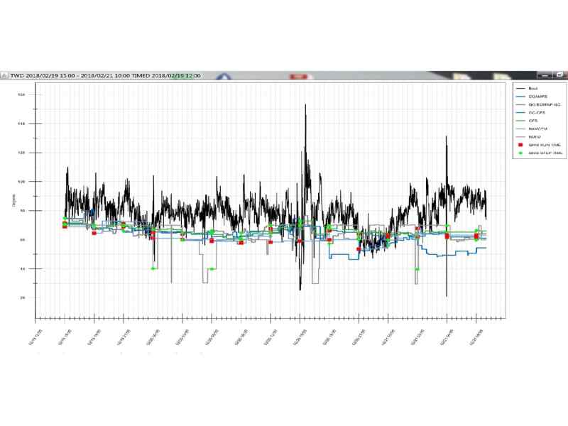
Navigators use routing software to figure out where to go and how to get to the finish line first. When a routing software platform (e.g., the Expedition software) generates an optimal route it applies the boat’s performance files (commonly known as polars or VPPs) to the weather forecast GRIB files. Sailing teams invest heavily into refining and perfecting the boat’s polars, but when it comes to the GRIB file, we’re left to choose which source we think is best, what was recommended, or even our own bias for GRIBs we’ve paid for from a private forecaster. Everyone who makes a GRIB file (e.g., PredictWind, GFS, COAMPS, EC, etc.) think they produce the best file. To put this in perspective, within the Expedition software it is possible to download nearly 75 different types, resolutions, and sources of weather forecast GRIB files at various locations around the world. How would you choose which is the best one and most accurate? That’s where Model Accuracy comes in.
The software logs compare instrument weather data from a sailboat’s instruments to any weather forecast GRIB files. That data comparison is then used to generate an overall score of accuracy for each weather file source. It’s a statistical analysis providing individual GRIB file calibration values, and graphical displays of what the weather forecast files predicted the true-wind speed and true-wind direction to be versus the actual conditions experienced on the water by the sailboat. You can now always know you’re navigating off the most accurate forecast file, anywhere in the world. Also, before you even cast off, you can use NOAA weather buoy data to create a forecast analysis before your race. By determining which GRIB file is trending as the most accurate on your racecourse in real time, you can begin routing your boat on the best GRIB file possible before the race even starts. Then, as you begin sailing, you can compare your logged wind data against the GRIB files and further refine your selection and calibration of the best source of weather forecast GRIB files.

During the 2016 Pacific Cup, I navigated RIO100, the 100-foot super maxi. Correctly calling when to jibe from starboard to port and nailing the approach to Hawaii is critical for this racecourse. Over the course of the first two days of the race, I downloaded a series of weather file GRIBS. Using Model Accuracy I was able to statistically compare all the weather forecast GRIB files I had downloaded to our boat’s logged wind instrument data and discovered the GFS weather model was clearly the most accurate source. However, even though GFS was the most accurate weather file for this part of the ocean, it still had trend errors. I could also see the GFS was forecasting the true-wind direction slightly right of what we experienced on the water and forecasting more true-wind speed than we were experiencing. I then was able to focus my attention on when to jibe using my top performing GRIB file, which I had even calibrated within the Expedition software for the errors trends we saw on the water, as recommended by Model Accuracy. The result was a new optimal route that encouraged us to dig further into the corner another two to three hours on a 1,000-nautical mile layline. Arguing for hitting the corner wasn’t easy. But the data was there, backing me up, in the middle of the ocean. We broke the existing course record by nearly 3 hours. Also, I was able to stop downloading weather files that were underperforming via satellite, saving the team a considerable amount of money.
Model Accuracy was built to be as simple of an interface as possible and ultimately be the “consumer report” of weather forecast GRIB files to help you choose which one to trust the most within your routing software. All it needs to work is instrument log files and GRIB files that overlap in position and time. That’s it.
We are really excited about what lies ahead for our start-up company. We are working on incorporating racecourse mark weather instrument data to assist race committees and coach boat instrument data for Olympic sailing teams. As these users sail in the exact same venues year after year, their data can really help identify which forecast is most likely to be accurate. The days of “gut feeling” and local knowledge are passed, and science and statistics are in. We have the algorithm to correctly value forecast trends against the actual conditions captured, and can help identify which GRIB file to trust the most and why. We are also working on a way to optimize your own weather forecast GRIB file based on trends you verify in the middle of the ocean. Download the software today for free from www.ModelAccuracy.com and test it out in restricted mode. The software is available for purchase on an annual subscription. One-on-one screen share is available to any new potential customer.

")


