SailflowHouston2006
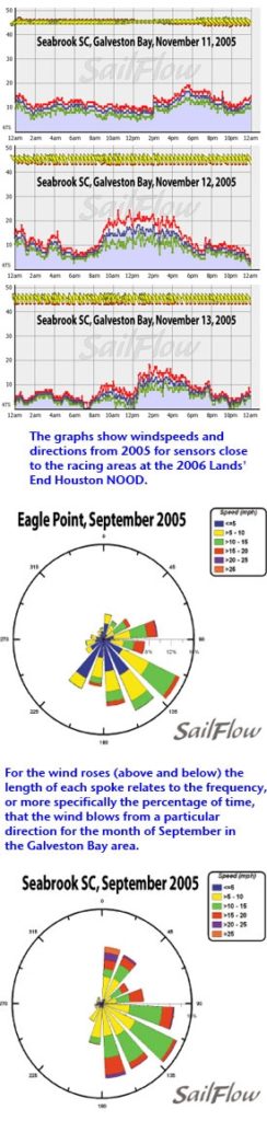
While other parts of the country transition into fall with an increased number of stronger frontal systems, Texas generally remains shielded from the fronts by the placement of the jet stream. Occasionally, usually towards the end of September, a cold front will stir southwest flow through the region.The frequency of tropical systems typically declines through September (although last year Hurricane Rita forced the postponement of the Houston NOOD). So far this season the Gulf has been fairly quiet in terms of tropical activity, but pay careful attention this week, as tropical waves and energy can significantly alter wind patterns. Sea breezes often develop along the immediate coast in the afternoon hours, complicating wind patterns for sailors. With Galveston Bay water temperature remaining in the 80s and inland temperatures pushing well into the 90s, the resulting thermal gradient along the coast can locally enhance wind strength and direction, occasionally veering winds as much as 90 degrees. The strength and direction of a sea breeze wind is tied to a number of factors, including the strength of the coastal temperature gradient, orientation of the coastline, cloud cover, and prevailing synoptic winds, therefore, anticipating the sea breeze pattern can be very tricky for sailors near shore. The accompanying wind roses give a taste of September winds for two sites within Galveston Bay. Seabrook Sailing Club is a Sailflow weather station and Eagle Point is run by NOAA. Both locations show an overwhelming tendency to east and southeast flow. This tends to be the dominant direction for September, reflecting strong sea breezes.Also included here are the exact wind graphs for Galveston Bay during last year’s regatta, which took place November 11-13. The first day of the event, the winds started easterly and veered to southeasterly, with and mid to late afternoon peak. This is the signature of a typical sea breeze, with gradual veering throughout the day. The second and third days of the event were highlighted by a frontal boundary setting up inland, thus afternoon sea breezes coupled with the prevailing SSE flow to create much stronger winds. These fronts are more common during late fall, when last year’s regatta took place, and it’s no surprise that winds were so strong. With this year’s regatta taking place in September, sailors may not experience such strong winds.
Author’s Note:Knowing what forces are driving the winds is of great importance to gaining the edge on your competition. Sailflow.com provides real-time sensors as well as complimentary forecasts throughout the race period at www.sailflow.com/houston. In cooperation with North Sails, Sailing Weather Service is offering free precision race forecasts for this event. Sign up at here.